Will Evolving Drones Shape Future Landfill Operations?
Some innovators are working on drone-bound sensors to measure methane, other landfill gases and more.

Landfill operators have been putting cameras that capture imagery and data on drones for a few years to, for instance, calculate airspace. But a few innovators are working on a new concept: drone-bound sensors to measure methane and other gases and, in some cases, to do more.
One company is fine-tuning technology to automate the federally regulated surface emission monitoring (SEM) procedure. Another is doing interesting work with drones and laser. And a university researcher is looking to combine multiple drones’ abilities to boost their potential power.
Sniffer Robotics’ patent-pending technology programs a preplanned path that the drone flies.
“We designed the system to ensure that the New Source Performance Standards (NSPS) requirements for spacing (monitoring every 30 meters across the landfill) can be met. It collects samples from the required distance from the ground. And it reports gas methane exceedances to surveyors in the required timeframe,” says David Barron, chief technology officer for Sniffer Robotics.
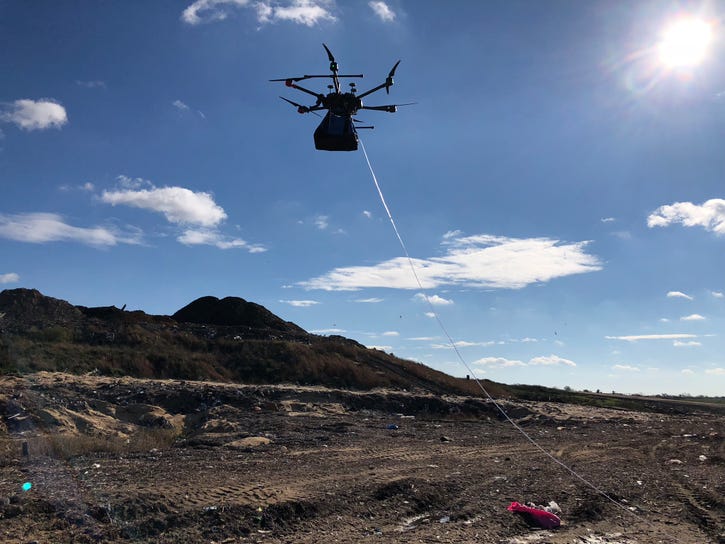
A sample inlet is dragged across the landfill surface; a pump located on the drone transports the collected gas to the detector, which is also mounted on the drone. The device captures methane values and an image and tags the image with GPS coordinates. Exceedance information is pushed to a web portal along with associated imagery of that exceedance location.
“Alternatively, the surveyor walks the entire landfill at 30-meter spacing. It’s an exhaustive and hazardous job. Meanwhile, this technology measures methane concentrations five times faster than manual inspection and it does so in single-digit parts per million. So, it reduces injury risk for workers and increases precision and efficiency,” says Barron.

There are still technical challenges to overcome. But Sniffer has demonstrated core competencies at test sites and is in discussions with site owners and regulators about the solution.
“We are closing in on being able to execute surface emission monitoring per current NSPS regulations (primarily, Method 21). But we are cognizant that Method 21 was not enacted with any notion of drones automating the SEM procedure, so we have just begun talks with the Environmental Protection Agency (EPA). We need to make the regulatory community comfortable with the method and integrity of the data,” says Barron.
As Sniffer fine-tunes the features around compliance, site operators are still using the technology for methane monitoring.
Bridger Photonics has a prototype that incorporates a drone that flies a preprogrammed flight and light detection and ranging (LiDAR) technology, which illuminates a target with a laser. The technology enables measurement of gas that’s between the sensor and a specific point on the ground.
“If I know where the sensor is when the measurement is taken, and I know the distance between the sensor and where the laser beam hit the ground, then I know the coordinates of every point. I can say this is how much methane was in the atmospheric line between the sensor and this specific point on the ground. This allows me to make spatial maps of methane concentration for various purposes such as leak detection and emissions monitoring,” says Mike Thorpe, chief technology officer of Bridger Photonics.
The company, which has funding from the Environmental Research & Education Foundation, has proven the technology can map methane concentrations and identify hot spots and is now working to prove it can be an alternate technique to the Method 21 surface monitoring process.
Photonics is also beginning to work on a more efficient method for determining emission rates across whole landfills.
“We proved the method to measure emission rates at an oil and gas facility at Colorado State University. By fall, we will do the first landfill test to validate our results,” says Thorpe.
Researchers at the University of Michigan are mounting different sensors on one drone that test not only for methane but for other compounds like carbon monoxide to assess risk for underground fires and sulfites to help identify odor sources.

“By putting these [existing] sensors on one drone to scan the whole landfill, we collect data types for different purposes and get a more comprehensive picture of the landfill’s health or condition,” says Dimitrios Zekkos, an associate professor at the Department of Civil and Environmental Engineering, University of Michigan, Ann Arbor.
He and his team are also building integrative pieces intended to work with these drones to devise a comprehensive system.
“You need to collect data, but there are other necessary components like a data acquisition board that we are designing to integrate with the rest of the system. The goal is to provide a landfill health assessment methodology where we can integrate big data from multiple sensors flown on a drone and for that drone to be able to process it and make decisions in flight,” says Zekkos.
While there is much to be vetted, Zekkos says what is known to date is, “You can get more and better data at lower costs by flying many sensors at one time on one drone.”
About the Author
You May Also Like


